Showing posts with label history. Show all posts

February 28, 2022

History of the British countryside, part 2

Following on from my previous post, here is...

A simplified history of the British countryside, from the Stone Age to the present - Part Two

14th - 17th centuries

The early 14th century saw a boom in agriculture, woodland cover was down to 7%, and the population was around 7.5 million. After the Black Death of 1348-50, the population was down to 3.5 million. Deserted villages and abandoned farms were left unmanaged, so woods started to develop again. After centuries of being contained in private parks, rabbits escaped into the wild, and quickly became so numerous as to be seen as pests due to their grazing. The Tudors needed enormous amounts of timber for ships and forts – Henry VIII’s flagship the Mary Rose alone needed 1200 trees – and their large-scale removal of large and ancient trees, mostly oak, changed the appearance and wildlife of woodlands. In the 1660s, silviculture and plantation forestry began as landowners were encouraged to plant, grow, tend, and harvest trees for timber to support the Navy. Serious efforts to drain the East Anglian fens began.

Enclosure Acts, 1750-1850

As the population increased and more efficient food production was needed, and workers were required for growing industries in the cities, successive Governments passed Enclosure Acts for thousands of parcels of land across the country between the mid-18th and mid-19th centuries. These broke up and privatised previously open communal land and changed the face of the countryside dramatically. Barriers and boundaries sprang up everywhere to enclose the new private properties – walls, fences, hedgerows, banks, ditches, roads and tracks. Rights of Common were removed, denying people the ability to live off the land, and there was mass migration to cities. Inside the estates, some good habitat management practices like coppicing were continued by gamekeepers to provide good conditions for game birds, as game sports became popular with the wealthy new landowners.

18th - 19th centuries

Coppicing peaked in the early 18th century, as the new industrial furnaces needed 10,000 acres of coppice each. As the Industrial Revolution took hold, coal became the preferred fuel, and large timber was needed for coal mine pit-props and railways. As coppice and other habitats declined, so too did a wide range of species which relied on them. Botanists explored the world and brought back exotic plants, including ornamental but invasive rhododendron and new fast-growing conifer trees for forestry. Many landowners turned to sheep grazing due to the high value of wool, and we still see the legacy of this today in areas like the Lake District and Scotland. The Victorians straightened many rivers to create more usable land and to try to prevent flooding by allowing water to move more quickly through an area. Muntjac, Sika, and Chinese Water Deer were introduced from Asia and soon escaped into the wild.

World War One and Two

Declaration of war in 1914 meant another increase in demand for timber, both for the trenches and for mine pit-props to ensure a supply of coal for Royal Navy ships. Trade links were almost completely cut off, preventing cheap imports, which resulted in more woodland inclosures being felled. By the end of the war woodland cover was at an all-time low of just 5%, so in 1919 the government established the Forestry Commission to ensure a supply of homegrown timber for the future with fast-growing conifers. Farmers had to produce more food with fewer labourers and horses so tractors were introduced, and the “Ploughing Up” campaign led to an extra 2.5 million acres being turned over to growing wheat, oats, and potatoes. In World War Two, a similar campaign meant the area of arable land in the UK increased by 50% in just five years.

Mid to late 20th century

Following WWII, agriculture and forestry intensified further, and even into the 1980s hedgerows were being dug up to create larger fields. However, the need for people to be able to access the countryside for wellbeing was also recognised and National Parks, nature reserves, and Areas of Outstanding Natural Beauty were created. In the 1950s, disease decimated wild rabbit populations, and, without their grazing controlling regrowth, many grasslands became overgrown with scrub and trees. The following decades saw rapid advances such as increased mechanisation, introduction of new crops like the now-widespread bright yellow oilseed rape, and increased pesticide use. Environmental awareness spread during the 1980s, and agri-environment schemes were established to encourage landowners and farmers to take actions that benefit certain species or habitats.

Present day

Today, around 65 million people live in Britain, and to the 85% of those who live in towns and cities the countryside is largely regarded as a place of recreation rather than work and survival, although around 70% of land area is farmland. There are still many pressures, changes, and challenges: the constant construction of new housing estates, polluting industries and lifestyles, species decline and biodiversity loss, climate change. However, the ecological importance of a diverse range of habitats is more widely understood, and there are widespread efforts to restore woodlands, grasslands, hedgerows, heathlands, river meanders, and wetlands; reinstate traditional management methods, upon which many species depend to create the conditions they need; and reintroduce nationally-extinct species. Understanding the history of the land may help us create a sustainable future. 


Modern farmland in winter


February 19, 2022

History of the British countryside, part 1

I love history, and I love the countryside. One of the very first lessons we had at college at the start of last academic year was, to my delight, on the history of the countryside. I wanted to write about it back then, but never got around to it. But then last term we had a Specialist Project unit at college, so I decided to create a booklet on that very subject :)

The booklet was submitted just before Christmas, so the text for this post has been written for about two months. I did want to add to it, to include more interesting things I found in my research that I didn't have room to put in the booklet. But because I made the booklet directly from the notes document and not in a separate one, the notes I omitted no longer exist, and I just don't have time right now to re-do it all (or go back through the document Version History), sadly. So here it is...

A simplified history of the British countryside, from the Stone Age to the present - Part One

Key terms:
  • BCE = Before Common Era (instead of BC) 
  • CE = Common Era (instead of AD) 
  • c. = circa = around, roughly 
  • Tundra = open arctic landscape of lichens, mosses, short grasses, dwarf shrubs, reindeer and wild horses 
  • Aurochs = ancient wild cattle, up to 2m tall at the shoulders, became extinct in Britain in the Bronze Age 
  • Coppicing = periodic cutting of tree stems to allow regrowth of multiple stems – sustainable way to produce wood 

Mesolithic ("Middle Stone Age", c. 10,000BCE - 4500 BCE)

At the end of the last Ice Age, the climate began to warm. As the ice retreated, the land slowly transformed from treeless open tundra, to boreal forest of pine and birch, to dense broadleaf woodland – the “wildwood”. Animals such as red deer, boar, and aurochs migrated up into this north-western corner of the continent, and humans followed. The natural grazing processes of these large herbivores created a shifting mosaic of woodland interspersed with open areas of grasses, flowers, and small shrubs – trees covered about 60% of land area. Humans were nomadic hunter-gatherers, following their food, and had a relatively small impact on the landscape - although not none. Some began to create clearings to attract the herds and allow fruiting plants to grow, for easier hunting and foraging. The land between what is now Britain and Europe was slowly taken over by rising sea levels, finally creating an island around 6000 BCE. 

Neolithic ("New Stone Age", c. 4500 BCE - 2200 BCE)

Small-scale human organisation and impact on the land increased as rudimentary agriculture with crops and domestic animals reached Britain, and humans began living in more permanent settlements. Quarries and mines were established for flint and other useful stone. Settlers made use of difficult areas, for example by building wooden trackways across fens and marshes. Woodlands started to be cleared and managed – coppicing began – and after a few generations the loss of nutrients on well-draining soils meant that trees could not regrow: grasslands and heathlands established, and were used for grazing. Watercourses would have become cloudier with silt as soil washed into them, no longer held together by living tree roots. By the time Stonehenge and other monuments were created there were large areas of open land with views unobstructed by trees. 

Bronze Age and Iron Age (c. 2200 BCE - 43 CE)

Better metal tools meant easier, faster tree clearance for settlements. The first field systems were established, in some places marked out with stone walls known as ‘reaves’ which can still be seen today. Mines for copper, gold, and tin were created. Coppicing increased to produce charcoal, which was needed to fuel the smelting of copper and tin for bronze. By the Iron Age, small settlements and farmsteads scattered the land, surrounded by fields of crops and pastures for livestock. Woodland clearance continued to increase, as did coppicing for smelting iron. The introduction of iron-tipped ards (an early type of plough) meant heavier soils could be cultivated. Humans had organised into large regional tribes, and on hills across the country the treeless slopes were dug up to create ramparts of steep banks and deep ditches, known today as hill forts. 

Bronze Age burial mound

Roman occupation (43 CE - 410 CE)

The Roman conquering of England and Wales brought enormous change, and their engineering innovations left huge marks on the landscape. They created the first urban infrastructure, building towns and cities, 16,000km of roads, and canals and aqueducts carrying water to the towns, as well as military forts and luxurious villas with formal gardens for the landowning aristocracy. The landscape became more planned and regulated, with clusters of farms serving an estate, and, as war-going people who needed timber and money, the Romans began to manage woodlands as commercial crops, and hay meadows for animal feed. Non-native plant and animal species were introduced, including rabbits for meat and fur and the sweet chestnut tree for nuts and timber. Their heavier iron plough allowed expansion of farming, and in some places Roman field systems are still in use today.

Anglo-Saxon period (410 CE - 1066)

The Germanic tribes that came to Britain after the Romans left were farmers, so lifestyles largely reverted to those of pre-Roman times. Coppice woodlands were divided into compartments for families and villages, marked out using boundary wood banks, and the practice of leaving “standards” within coppice – selected trees left to grow naturally as one large stem for timber – began. Scattered farms with enclosed arable and pasture fields were replaced with villages and open strip fields farmed communally – as a result, wood pasture for livestock grazing increased too. Eventually towns began to establish again, and estates linked to the early Christian monasteries. The composition of tree species around the country was affected by a warming of the climate between around 800 CE and 1300 CE, known as the Medieval Warm Period. 

Norman period (1066 onwards)

William the Conquerer designated huge areas of land as Royal Forest, i.e. hunting parks – originally, “forest” meant an open area given over to hunting. 90% of the population lived in the countryside and were suddenly banned from hunting deer, wild boar, and hares, but in return Rights of Common were established, which allowed people to collect firewood, graze livestock, and dig turf or peat for fuel, among other things. Hunting favoured open areas, so many grasslands, heathlands, and wetlands were protected and kept open – and survived for centuries because of this. Meadows increased in area as hay became more profitable than grazing, and most floodplains were utilised as meadow. The Normans also introduced pheasants and fallow deer, and re-introduced rabbits.

--

Next week I'll cover the late medieval period to the present day. If you like this sort of thing, I recommend reading Nicholas Crane's The Making of the British Landscape. Archaeologist Francis Pryor has a book of the same name and that looks good too. Oliver Rackham's History of the British Countryside may appeal to those with more of a scientific interest, I didn't find it to be very easy reading and the chapters are by habitat type rather than in chronological order. And Yuval Noah Harari's Sapiens is fascinating in terms of humanity's general development and how we changed from being one of numerous human species, very much a part of the ecosystems we inhabited, to being the only human species and dominating everything.


February 12, 2022

Museum visit

If you like such places, I recommend a visit to Salisbury Museum. I went there last weekend and really enjoyed it.

They have an excellent new exhibition on for the next few months, 'Ancient Sites from the Air' by photographer David R. Abram - aerial photographs of ancient sites across the country. Each image was created by stitching together hundreds of individual photos taken from a drone moving over the site - so each one is really high resolution and super detailed. It's really impressive. Plus they're just cool photos anyway, quite abstract. 

Two of my favourite images in the Ancient Sites from the Air exhibition by David R Abram. You're encouraged to take photos in here (not the rest of the museum though), for personal use and for social media use to promote it. 

The state of the art Wessex Gallery of Archaeology is great too, which has thousands of finds from prehistory to the Norman period. The museum website says it's one of the most important archaeological collections in the country outside of London, with many artefacts from the Stonehenge landscape, Old Sarum, and Wiltshire as a whole, including the Pitt-Rivers Wessex Collection. Lieutenant-General Pitt-Rivers was the first to use a scientific approach to exploring and excavating historical sites, as opposed to just digging and looting without any method or recording, and so laid the foundations for modern archaeology. 

I really liked the largely intact 4th-century mosaic found in the village my family used to drive through regularly on the way to see my grandparents. I was impressed with just how much time and care it would have taken to remove it from the site and then put it together again. The website says the latter took 3 weeks. 

Out of everything in the Wessex Gallery, though, I think my favourites were the oldest objects in there: the 450,000-year-old stone handaxes. Simply because of how mind-bogglingly old that is. 450,000 years old! That's from an inter-glacial period, waaaay before Britain was permanently settled. 

What was just as mind-boggling was the meteorite in the corridor. It's just a 90kg ball of rock. But it's 4.5 billion years old. And not from Earth. If it was from Earth it would be one of the very earliest rocks. It's from outer space. The asteroid belt to be precise. Obviously I know that meteorites are from outer space, but I've not actually seen one before. So cool! 

Finally, the museum cafe does good lunches too - I recommend the mushroom lasagne :)

I've always loved history and archaeology but it's fallen by the wayside over the last several years. I was disappointed to find out I'd missed 8 series of 'Digging for Britain' when I watched the new one a few weeks ago. It's nice to be getting back into it all. 

This may have just been a load of waffle, haha. Next week I'll finally publish what I was originally going to post now - the first of two posts on the history of the countryside :) 

September 12, 2019

Lake District August 2019 - day 3

For the Thursday I'd booked myself onto an all-day organised group tour with Mountain Goat, which does tours over the north of England - Lake District, Manchester, Yorkshire - and North Wales. I did the High Adventure, covering the western Lake District and taking in the Langdales, Blea Tarn, Hardknott Pass, the Ravenglass and Eskdale Railway, and Muncaster Castle, as well as a lot of great scenery.

I was picked up at 9:30am at a bus stop just a five-minute walk from my B&B, and the only other people on the minibus were a middle-aged couple from Texas. As we left the town, heading south towards Grasmere, the driver/guide explained that "Keswick" is a Viking name, coming from the Old Norse for 'place that cheese is made'. Nowadays it's more known for making the famous Derwent Pencils, after graphite was discovered in the 16th century. There's even a pencil museum in the old factory. I made a note of everything the guide said as we made our way through the countryside towards the Langdales:

  • The Lake District is England's largest National Park, at 900 square miles. It has a permanent population of 30,000, which increases by 18 million or so every summer. Generally, the first snow falls in November and the last of it melts in April. Keswick's elevation is only 100-120 feet (30-36m) above sea level, though, so other places get more snow.
  • Several hundred years ago the whole area was forest. The landscape we see today was created by humans and is very heavily managed. Trees are starting to be replanted, but many worry that it is too late, that the damage to the landscape is done.
  • Thirlmere is a reservoir created by the Manchester City Corporation at the end of the 19th century to supply water to the city. It used to be two natural lakes, and the name comes from Old Norse.
  • Most of the rock in the area is metamorphic, i.e. slate or granite. Different minerals in the rock result in different colours, so pink slate, seen closer to the coast, comes from the presence of iron oxide, and green slate from chlorite, etc.
  • We passed through Dunmail Raise, a low-level pass that joins the northern and southern parts of the Lake District. The name comes from a cairn located in the pass, which, according to folklore, is the burial place of Dunmail, the last king of Cumbria. The guide said after Dunmail's death his land eventually ended up as part of Scotland; indeed, online sources say that the name Dunmail could have come from the real 10th century king of Strathclyde, Dyfnwal ab Owain, and that the cairn could have been a boundary marker between the kingdoms of Westmorland and Cumberland, and/or marked the southern extent of the kingdom of Strathclyde.
  • There is a heavy Viking influence in the Lake District, particularly in the language: lakes are meres, mountains are fells, valleys are dales, streams are becks. 'Gras' in Grasmere is from the word for pig or boar, and Windermere used to be known as Winandermere, from 'Winand's lake'.
  • When the Vikings arrived they found the native people living mainly by the coast. They were happy to settle more inland, in mountainous landscapes they were more familiar with.
  • The Lake District has approximately 5000 miles of drystone walls, and most are at least a couple of hundred years old. They were created following numerous Inclosure Acts, which encouraged landowners to enclose open fields and common land so they could have legal property rights. This meant that many tenant farmers were either offered compensation to leave or were unwillingly forced to, so that landlords could use more efficient and productive methods to farm.
  • Drystone walling is very expensive; the guide said he recently paid £1500 for 10 metres. The stones that stick out from the top at an angle are called coins and are integral to the structure; if they get knocked off then the wall crumbles, so most farmers put a wire fence in front of the wall to protect it - so don't go sitting on top of a drystone wall! Not that I'd imagine it would be very comfortable anyway.
  • We passed the village of Elter Water, a pretty little place which was bought by a timeshare company - so house prices skyrocketed and young people, the next generation of farmers, were priced out and forced to leave. The same is true of a number of other villages. Ugh.
  • Herdwick sheep are born black and gradually become white over the years.
  • The National Trust own around 25% of land in the Lake District, much of which they were bequeathed by Beatrix Potter. She was a keen conservationist and sheep farmer, and used the royalties from her books to buy a number of farms because she wanted to protect and preserve the unique landscape, and the not-very-profitable Herdwick sheep which she loved.

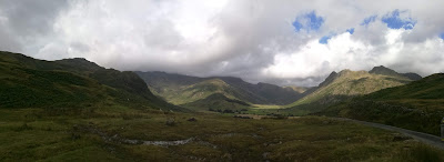
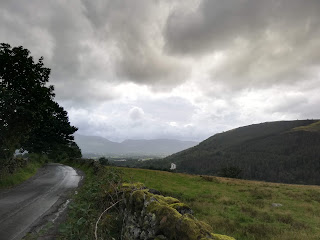
In Great Langdale Valley

After driving through the Great Langdale Valley, we moved up into Blea Tarn Pass, a hanging valley which connects the Little and Great Langdale Valleys. (A hanging valley is basically one which drops down into a larger, wider one - think of a mountain valley with a river, leading to a big waterfall where the cliff drops down and there's a huge valley below.) Blea Tarn is a small lake, 'blea' meaning blue and 'tarn' from the Viking word 'tjörn', meaning teardrop. It's actually a SSSI (Site of Special Scientific Interest) so going in the water is prohibited. We stopped for photos at a point from which we could see the Great Langdale Valley and Blea Tarn, and I gazed much more at the valley we'd just come through. A peregrine falcon danced overhead in the wind.

Looking towards Great Langdale Valley from Blea Tarn Pass
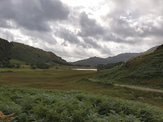
Blea Tarn

After getting back in the minibus we continued down to Little Langdale and past Fell Foot Farm, which has been in the same family for several generations. They came there because an ancestor used to make whiskey illegally (moonshine) in nearby caves; he got rich and bought a sheep farm, casting his descendants into poverty - there is little or no profit in sheep farming, so farmers basically live on subsidies and manage the land.

From Little Langdale Valley we went into Wrynose Pass ('pass of stallions'), which has a single-track road and some of the steepest inclines in the country. We stopped at a viewpoint and could just about see the Yorkshire Dales in the far distance. The road continues down to Duddon Valley and then up again into Hardknott Pass, where it becomes the steepest road in England with a gradient of 1 in 3. (I had to look up what that means: for every three units you move horizontally, you move one unit vertically. E.g. move 1m up for every 3m forward.) It's regarded as one of the most challenging roads in the country with some very tight hairpin bends in addition to its steepness; minibuses are only able to go down it from Duddon to Eskdale, not the other way around. There is an old Roman fort in the pass, which I would have really liked to see, but sadly we didn't stop.

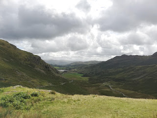
View from Wrynose Pass

Included in the tour was a trip on the Ravenglass and Eskdale Railway, often known as "La'al Ratty", a heritage narrow-gauge line built on the route of a wider one used to transport iron ore out of Eskdale in the late 19th century. We arrived at Dalegarth station and the guide saw us onto the 11:50 steam train to Ravenglass, the only coastal village in the Lake District National Park. The seven-mile trip would take about 45 minutes and the weather was cloudy but dry so I decided to sit in a carriage with a roof but open sides. It was good! The train was only half full, though we passed one going the other way which could not have fitted another person on it. That one had a beautiful bright blue steam engine and the driver had a gorgeous chocolate spaniel puppy sat next to him, which must be very well trained to not jump out!

At Dalegarth station

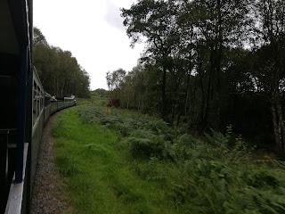
On the train to Ravenglass

The downside of sitting in a carriage with open sides was that, as we arrived at the estuary and neared Ravenglass, a gust of wind blew something into my left eye. Whatever it was wouldn't go away, and it felt like I had an eyelash in there that wouldn't shift, and I spent the rest of the day in discomfort and painful irritation every time I blinked. Booooo. Fun fact as we left the station, though: a finger-post pointed towards the towns at either end of Hadrian's Wall (Bowness-on-Solway 55 miles away on the west coast, and Wallsend 139 miles away on the east coast), and Rome, 1127 miles away. Ravenglass, with its estuary and natural harbour, was an important naval base for the Romans; it was the most southerly point of their Cumbrian coastal defence system, and so a sort of extension of Hadrian's Wall and the empire's western and northern frontier.

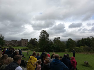
For lunch we stopped at nearby Muncaster Castle, still home to the Pennington family. It's one of those family attractions with a castle museum, gardens and grounds, a café and gift shop, children's play area, etc. We had two hours there so I mooched around in the gift shop for a little while, then went to get lunch - tomato soup and a bread roll - before going to the 2pm birds of prey flying display. The setting was lovely, in a meadow with woodland behind it, the pretty pink-hued castle to the left, and a view of the fells on the other side of the valley directly in front. I love birds of prey and I think this was the best display I've seen. They brought out a beautiful barn owl, a black-chested buzzard eagle, a Saker falcon (impressively fast! can fly up to 62mph), a Verreaux's eagle-owl (somewhat creepy black eyes), a few African hooded vultures, some yellow-billed kites, and another golden-coloured kite I didn't catch the proper name of. A wild peregrine appeared at one point, too. I like that these places make an effort to educate people about vultures, which are often misunderstood and disliked. They're great, and needed; they clear up things that would otherwise spread disease. A sad, infuriating fact they told us was that many poachers in Africa poison elephant carcasses after removing the ivory tusks, in order to kill vultures, because they think that the circling groups of birds give away their position to the authorities - in June 2019 alone 537 vultures in just one small area died from this poisoning.

Birds of prey display at Muncaster
Part of Muncaster Castle
"Tom Fool's Tree", the ancient sweet chestnut

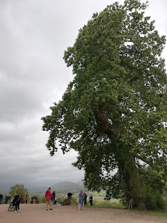
After the flying display I headed round the side of the castle, where I was happy to find an enormous, magnificent, ancient sweet chestnut tree, on the edge of the grounds where there's a great view of the valley below and fells beyond. We left Muncaster at 3:15pm and headed north along the coast. Catching a shimmering glimpse of the Irish Sea (and the Isle of Man can be seen on clear days), we passed Sellafield. It used to be a nuclear power station but is now a reprocessing plant for used nuclear fuel rods from all over the world, and an authority on nuclear power station decommissioning. The site directly employs 10,000 local people. There's a big area of sand dunes near Ravenglass, which gradually turn to low plains, rising to fells covered in darkening clouds and softly obscured with rain. Moving inland the landscape becomes gentle rolling farmland, then low, broad, grazed, treeless fells which reminded me of Dartmoor. Due to their proximity to Sellafield, the local villages like Ennerdale Bridge are quite well off, unlike the old mining villages elsewhere which are quite deprived. The guide didn't say anything about Ennerdale valley itself but I know that it's somewhere I'd like to visit one day, because the place is basically undergoing rewilding - they're leaving nature mostly to its own devices and letting it return to wilderness. Vehicular access is prohibited, the nearest road being a couple of miles away, so you can only reach it on foot, possibly bicycle. I'd love to see it way in the future, when it's had a lot of time to recover and flourish; it's only been 10 years so far. The project's vision about it being "for the benefit of people" is a minor irritation, though, as it'd be great if there were some places just for the benefit of nature and wildlife rather than humans, but it's still an exciting project that needs to be done in many more places across the country and world.

We passed a village with a Scottish name, Kirkland, and you can see Scotland from the area on a clear day. Before the 16th century this part of what is now northern England considered itself neither English or Scottish. Border Reivers were notorious, clans raiding all over the Border country regardless of victims' nationality, those struggling to survive robbing and killing those who were also struggling to survive. They left their mark on the English language - bereavement, blackmail, etc.

Moving down into the Vale of Lorton the land becomes more fertile, with hedges instead of drystone walls, and cows instead of (or as well as) sheep. It leads to the Whinlatter Pass, where the Whinlatter Forest is owned by the Forestry Commission, which was set up in 1919 to replenish the UK's timber supply after World War I. Scots Pine is the UK's only native pine and one of only three native conifers; others were introduced by the Forestry Commission to be harvested.

Bassenthwaite Lake

The lake to the north of Keswick, which I'd seen after coming out of the Whinlatter Pass on the public bus route the day before, is Bassenthwaite Lake, the only 'lake' among the 16 bodies of water that make up the English Lakes. The others are either 'meres', named by the Vikings, or 'waters', named by the Victorians. Being on a flood plain between Bassenthwaite and Derwentwater, Keswick can get flooded easily, and of course suffered heavily in the 2009 and 2015 Cumbrian floods. The water level of the River Greta, one of two which flow through the town, was several metres below the tops of the flood barriers when I was there, but during the floods had broken over the top of them.

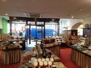
We got back to Keswick shortly after 5pm. The twice-weekly market had almost finished packing up, but the shops were still open so I went into Ye Olde Friars, the chocolate shop established in 1927 and still run by the same family. It was surprisingly big in there, spread over what would have once been two separate premises. After wandering around the whole place, I bought a dark-chocolate marzipan log and a selection of their individual handmade chocolates: spiced cranberry truffle, rose cream, dark choc ginger, dark choc marzipan, praline shell, and an almond truffle. Yum!

Ye Olde Friars of Keswick

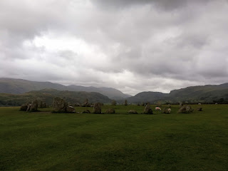
I went back to the B&B to change into my walking boots and waterproofs, and have a snack of gingerbread and a bite of Kendal Mint Cake for energy, as I wanted to walk up to Castlerigg Stone Circle, just outside town. It was a 30-40 minute uphill walk to get there, but definitely worth it; I broke into a big grin and an "Oh wow!" the moment I got clear of the roadside trees and saw it. With its hilltop position providing an amazing 360-degree view of the surrounding fells and valleys, it is undoubtedly one of the most dramatically and atmospherically situated stone circles in the whole country, and the low clouds and rain which had arrived during my walk made it even more so. I loved it!

Castlerigg Stone Circle
View when walking back down towards town
River Greta in Keswick

Apart from the grazing sheep, I had the place entirely to myself for about 15 minutes until a family arrived. I could have stayed there gazing around for longer but there aren't any benches and I wanted to get to another viewpoint on the lakeshore. So I left and made my way back down the hill, through the town, down past the theatre and the boat landings, and along the shore to Friar's Crag, a popular viewpoint just a ten-minute walk from the boat landings. It gives a great prospect down the length of Derwentwater to the "jaws of Borrowdale".

Keswick boat landings on Derwentwater
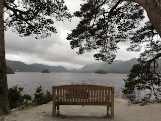
Friar's Crag viewpoint

Very hungry by now, I went for dinner at a trendy little independent place called Fellpack. There were no tables free inside but thankfully the weather was dry and it was mild enough to sit outside. Their food is seasonal and I ordered their Italian Tuscan bean braise with kale, sundried tomatoes, and Mediterranean squid. It was delicious, as well as healthy, hearty, and wholesome :) Part of me wanted dessert, their amazing-sounding rice pudding with sour cherries and toasted almonds, but it was pricey and I was tired and my eye was bothering me, so I went back to the B&B, had a couple of chocolates, and went to bed. Maybe I should make that pudding myself at home one day soon.

Fellpack in Keswick
Tasty dinner - Tuscan bean braise with squid

October 04, 2018

Summer 2018 big trip - day 24.1

Monday 20th August, part 1


Singaporesingaporesingaporesingaporesingapore! Singapore. Yaaaaaaaaaaaay! Finally. Now I was very excited to be here, I had been looking forward to it for months.

Apart from the few days in Sydney, I had spent the whole trip in the Tropics – the latitudes between the two Tropics of Cancer and Capricorn – so it had been very hot and very humid in both Queensland and Bali. But this city-state is smack bang in the centre of the Tropics at just 88 miles north of the equator and my goodness do you know it when you step outside. The airport and the MRT (metro) trains and stations are air-conditioned, so when I exited the station at Chinatown, where my hostel was, I just hit a wall of heat and humidity like nothing I've experienced before. Thankfully, a lot of the pavements are covered, so you can get some respite from the sun at least, and every building is air-conditioned.

On trips, if I'm by myself, I always go on a free guided walking tour on my first or second day in a new city, and had booked onto a five-hour one (!) for the afternoon of my first day here. My flight was due to land shortly after 9am and the tour wasn’t until 1pm, but my flight was delayed and then it took longer than expected to get to my hostel in Chinatown, so I didn't arrive till about 12:30. I called the tour company and asked if there was somewhere I could meet the group as I wouldn't get to the starting point in time; thankfully they said I could meet the group at a hotel in Chinatown where they'd be taking a short break. I left my bag at the hostel as I couldn't check in yet, and found my way to the hotel. After 45 minutes of standing outside getting increasingly concerned (and hungry, as I hadn't had a chance to have lunch), I was relieved when the group turned up, led by a bright and cheerful Singaporean woman whose English name was Priscilla.

The tour was excellent, the best I've been on anywhere. It was in the downtown core area but completely off the tourist trail. There were only six of us in the group, too, which was nice. The hotel I met them in started life as a Chinese temple; there's a low little wall several inches high across the doorway which you need to raise your feet to step over, which acts as a flood barrier, a symbolic threshold from the mundane to the spiritual, and has the function of making you do a little bow as you enter (in the act of stepping over something relatively high, you naturally lean forward as you put your foot down). It then became a museum, and is now a heritage-listed building, so the hotel has to let the public in to wander round the ground floor, where it's still a small museum. After a break sitting in the air-conditioned lobby, we went back outside and Priscilla led us to a traditional Chinese bakery. It's one of those with the open store-fronts, and lots of boxes with bags of biscuits and things in. The tour included some food tastings, so here we got the first one of some tapioca wafers (large thin circles, brightly coloured) and black sesame caramel sticks.


Many of the older buildings in the city centre are the traditional dwellings called shophouses: terraced buildings two or three stories high with a shop or other business on the ground floor and living quarters above. In the city's early days, poverty was rife and these buildings were full to bursting with families, living conditions were awful. Many also have "five-foot-ways" out front, generally along the length of the street. These are five-foot-wide covered walkways, built for shelter against the frequent rain and hot sun. The buildings can be quite colourful and pretty, and some shops have little shrines outside the door on the walkway.

We visited Thian Hock Keng Temple, a beautiful Chinese Taoist-Buddhist temple on the edge of Chinatown. It started in the early 1820s as a small waterfront joss house, built by immigrants from the Hokkien region of China and dedicated to the sea goddess Ma Zu, where sailors and settlers could go to give thanks for their safe arrival. Nowadays it's a large, elaborately decorated proper temple with several buildings or pavilions centered around a courtyard. There are several large shrines, like chapels in a church – one to Ma Zu, one Buddhist, one Confucian, one for ancestral tablets, and a few others. Priscilla showed us how people pray there and explained a bit about the different shrines and the faiths. I've never been to a temple before, and this one was amazing, so beautiful and interesting, I loved it. The back wall of the temple, outside on the street, was decorated with a mural about the history of the city's Chinese population, and the designers of the modern building opposite the front of the temple included two large eye-shaped holes in the top of it to 'watch over' the temple and keep it safe.
Not a good photo, but you can see the mural and the 'eyes' at the top of the glassy building.

Due to the limited amount of land in Singapore, the vast majority of people live in high-rise subsidised public housing apartment blocks, built by the Housing and Development Board and so referred to as HDBs. Most if not all of them have a market (basic shops like grocers, hairdressers, bank, a small bakery perhaps) and food centre, or hawker centre, either as part of the building or nearby. Hawker centres are a bit like food courts with a variety of places to choose from and lots of tables, but are open-air (roof but no walls) and the stalls are run by independent hawkers (no chain places). They began to spring up in the 1950s and '60s as a more sanitary version of streetside mobile hawker stalls, where hygiene wasn't always great. The food is generally simple, very cheap (on average a couple of Singaporean dollars a meal) and can be very good. I've since found out that there are even a couple of stalls in the city that have been awarded Michelin Stars!

We stopped at Maxwell Food Centre for a proper break and Priscilla bought us a sugarcane juice drink to try. It was delicious! Lovely and sweet and ever so refreshing. For food, we got to try two typical Singaporean dishes: carrot cake, and chicken rice. Carrot cake in Singapore is not carrot cake as we know it – it’s basically an omelette filled with chopped radish. Very tasty though!


Now - chicken rice. Chiiiiickeeen riiiiice! Widely considered to be Singapore's national dish, it is now one of the dishes that I love because it is so simple and yet so delicious, if done well. Basically: poached chicken, rice cooked in the stock from the chicken, and a bowl of chicken broth. Omigod. Wow. Big smile!

After half an hour or so, Priscilla returned and we left to continue the tour, stopping next at the Singapore City Gallery, where there is a giant scale model of the island on the ground floor, which was really cool. On the same floor was an exhibition about this year's President's Design Award, which was about "Creating a better world by design"; the entries were designs for things that would provide solutions to a range of issues like homelessness and environmental damage. The first panel was about a special tent, based on those used in the military and extreme-condition explorations, which could provide privacy and security for women living in refugee camps, or decent shelter for other homeless people. Reading a small summary online, apparently the gallery is about how Singapore came to be, how the city was planned to be able to fit a large population onto a relatively small island (approx 50km/31 miles east-west, 27km/17 miles north-south), and how city planners continue to plan sustainably. I would have liked to have gone back to the gallery and had a proper look round all of it, but didn’t have time/didn't prioritise it on this visit.


I love how 'green' and environmentally-aware Singapore is. Everyone always says it's the cleanest city in the world, and it is very clean, it's probably true, it's great... but it's also a small island that has no natural resources of its own and is now completely urbanised, so it's had to develop very good waste-recycling systems, make use of renewable energy sources, and make a sustainable future an absolute priority. Apparently it's the only country to have green building regulations in its legislation. Priscilla told us that, by law, a building developer has to re-plant the same amount of land it built on, and on a horizontal plane. So if a new building takes up twenty square metres of land on the ground in the city, the developer has to fill twenty square metres of land somewhere else with plants (though that doesn't necessarily have to be in Singapore) - it cannot cover twenty square metres of the building facade with plants (as good as that is, too). I love that! Many more cities and countries need to learn from them and follow suit, ignore the selfish interests of Big Business such as fossil fuel companies, look to the long-term wellbeing of the planet and all of its inhabitants (not just humans), and stop acting as if sustainability, conservation and protecting the environment are at odds with economic development.

Our last stop was the ‘Pinnacle@Duxton’, in the Tanjong Pagar area. This is an amazing modern HDB building, consisting of seven 50-story blocks linked by two 500m-long sky gardens on the 26th and 50th floors. Uniquely, for this project the Housing and Development Board decided to hold a worldwide competition for its design, which attracted more than 200 entries. The sky gardens are terraces surrounding the whole structure, so you can wander round and get amazing views over the city in every direction. It's kind of like a park, on top of a building; there isn't any grass, but there are plenty of plants and trees, and a few seating areas. Looking south you can see some islands across the water, and to the north you can see some skyscrapers beyond the distant hills - Indonesia and Malaysia respectively, both so close. We had 45 minutes there, to wander at our leisure, before the tour ended and we all left.


September 06, 2018

Summer 2018 big trip - day 17

Monday 13th August

Last day in Sydney. We got on a Big Bus tour to see the city, but I'm sorry to say that I barely took any photos and didn't make any notes so can't really remember anything. Does anyone remember much of what they saw on one of those tours? I did love the city though, the history was interesting, and I remember the pretty, colourful old terraced houses with balconies, and the thoroughly modern high-rise covered in plants with a huge panel of mirrors facing downwards and angled so that sunlight could reach everywhere.


We'd booked onto a two-and-a-half hour boat tour of the harbour for the afternoon, and the bus tour got us to Circular Quay just in time. Thankfully it wasn't very windy or cold up on the boat deck, and the sun was out, so we could happily gaze out at the beautiful views of the stunning harbour while listening to the tour guide's commentary on the history of the place.


In 1770, Lieutenant James Cook and his crew on the HMS Endeavour were the first known Europeans to see Australia. They made first landfall on the east coast at what he named Botany Bay (due to the range of new-to-European-science plants, insects and animals they found) then sailed north, exploring and mapping the coastline. (In northern Queensland there is a town called Cooktown, and another called Seventeen-Seventy, and probably many more such references.) Not far from Botany Bay, Cook passed an inlet, noted that it looked to be a good and safe anchorage, and named it Port Jackson, but didn't go in. It would be another eighteen years before someone went in.

In 1788, having taken eight months to sail from England with a fleet of eleven ships carrying over a thousand people, Captain Arthur Phillip decided to venture into the little inlet Cook had marked as Port Jackson, and "had the satisfaction of finding the finest harbour in the world, in which a thousand sail of the line may ride in the most perfect security." We now know that it is the second largest natural harbour in the world after Rio de Janeiro, with 240km of coastline and 66 bays. Choosing a bay with deep water, good defence positions, and a source of fresh water nearby, he made landfall and named that particular bay after the Home Secretary at the time, who had authorised Phillip to establish the new colony - Lord Sydney. Sydney Cove is where Circular Quay now is, the one the modern city grew out from and is based around.

The colony of New South Wales, the first European settlement in Australia, was a penal colony - most of the settlers were convicts. Their sentences were either for seven years, fourteen years, or life, but of course, even if they managed to survive until being freed, they had no way to sail back to England. So most stayed, claimed some land, worked hard and made a new life for themselves. Brits in Australia are still referred to by Aussies as POHMs ("poms") - Prisoners of His Majesty.

Now, two hundred and thirty years after it was founded, Sydney is the size of Greater London but has a few million less people at 5.1 million. Sydney Harbour is a National Park and a heritage-listed marine park; since legislation introduced in the 1970s forbade anyone from 'putting muck into the harbour' as the tour guide put it, industry has moved out and the water is very clean. There are sharks. It's very sheltered, right next to the ocean but protected from it. It doesn't need dredging, but there are a lot of reefs and over a hundred shipwrecks. Most of the land along the extensive shoreline is public, either open to the public or set aside as a park, because the authorities didn't think it was right that only the richest should be able to enjoy the waterfront. I like that they did that! Of course, only the richest can afford most of the waterfront houses (and have their fancy cars displayed in glass-walled rooms to show off to tourists on boats), but many of them don't own the water frontage; so the public can wander along and sit on one of the pretty, white-sand, nearly-empty beaches directly in front of some millionaire's house, or just go for a stroll, if they so wish.


After a lovely couple of hours - boat trips are nice anyway but Sydney Harbour is amazing and beautiful! - we wandered around a bit, saw some of the old colonial buildings. It was getting dark, the lights were coming on, there was a park with tall globe lamp-posts and a fountain, it was pretty. We made our way back to Circular Quay to have a nice last-night dinner on the waterfront. The next morning, we'd go our separate ways - my mum and stepdad back up to Cairns, and my sister and I to Bali.

I really wished I didn't have to go.


August 31, 2018

Summer 2018 big trip - day 16

Sunday 12th August

I'm actually writing this, or the part about this evening anyway, on the day for a change, although it won't be published until I've caught up and written and published the rest of the days until now. It's because I've had the evening to myself in this wonderful little house we're staying in, and I want to write about it before I forget about it.

It's a quirky place, in a lovely residential suburb. The house is old and cold, and the lounge is dark. But I'm sitting here in one of the armchairs (which don't match each other or the sofa), with the tall standing lamp next to it spreading its warm light into the room, a blanket over my knees and the little gas heater on (it heats the room very well, but probably is far from energy efficient). It's perfectly cosy. The floor is dark wood, with a red rug over it. There are pictures (as in artwork, not photographs) on the walls and vases dotted around. There are DVDs of the Italian crime drama series Inspector Montalbano. The kitchen has a stovetop whistling kettle, a wooden board for bread and a bowl of lemons on the counter. There are eco-friendly chemical-free cleaning products and books on homemade things like that. Upstairs is a large lounge area which is light and open and airy, but warmer than downstairs, and there's a dining table covered in sewing materials. And, best of all, there are books in every room. Hundreds of books. Books on subjects I wish I knew more about. Travel and foreign countries and languages, cooking, history, literature/ fiction, plants, gardening, sewing and needlework and embroidery, art and crafts and more. I could spend a week here just in the house, devouring a treasure trove of books. Alas, I cannot, so I've just noted down a few that I'd like to find and read when I'm home.

My sister, mum and stepdad went to see Pink this evening. I didn't fancy going, and had a couple of options for what I could do for the evening, but after a day walking around Sydney Harbour, I felt like staying in, out of the chilly wind, and watching a bit of Netflix. I watched the last episode of Spanish drama Cable Girls, an episode of Queer Eye, and then a quirky French rom-com called Blind Date, which I loved. Such a lovely, relaxing evening :)

So, rewind... In the morning we walked from Waverton into the city centre. The route took us through the lovely suburb, which again reminded me of Vancouver, and brought us to the waterfront at Lavender Bay, where we were greeted with a view of the Harbour Bridge directly opposite. We walked along from there, eventually reaching Milsons Point and Luna Park, a fairground built in the 1930s at the foot of the bridge. The entrance gateway is the kind of thing that would be very creepy if the place was closed. I wonder why fairgrounds are like that, creepy when closed.


The suburb at the northern end of the bridge is called Kirribilli. I've since read that it's one of the city's most affluent, and it was very nice, though we only saw a very small part of it. There were trendy, quirky cafés and eateries and a wonderful market in the large underpass under the bridge road. My sister and I spent a long time wandering around the market before we went back to where our mum and stepdad were sat people-watching (they immediately told me they'd seen a woman who was me in 30 years), and we all started across the bridge.

I can't remember how long it took to walk across. The thing is enormous. It's over a kilometre long, and nearly fifty metres wide with eight lanes for cars, two for trains, one for cyclists and one for pedestrians. It's quite impressive that the designers in the 1920s thought ahead and decided that cars and other road vehicles would become commonplace enough that the bridge would need six lanes just for those (the two tramway lanes originally constructed were later converted to roadway as well). The bridge was nicknamed "the Iron Lung", as its construction brought vital jobs to the city during the Depression. In the shadow of the other end of the bridge is The Rocks, a pretty area of cobbled lanes originally established in the early days of the colony in the 1790s, when it was more of a slum. We wandered through but not really around it.

We stopped for lunch at one of the numerous waterfront restaurants on Circular Quay. Despite its name the quay is in a rather square U-shape, with The Rocks and the Harbour Bridge at one end and the Opera House on Bennelong Point at the other, with an art gallery and boats (from harbour tour boats to cruise ships) and shops and restaurants and more all along in between, and the skyscrapers of the CBD rising behind. Such a cool place! We sat outside, with a great view of the bridge, where they had notices everywhere warning customers about the seagulls, and spray bottles on some of the outer tables. One thieving bird swooped down and snatched a small fillet of battered fish from one woman's plate as she was still eating. Thankfully we were seated under a parasol, which provided a deterrent for the gulls as well as shade from the sun. I had barramundi with salsa verde and a lovely fresh salad - so simple, but so good. Fresh fish! *Grins* Yum. Also had a mocktail, a strawberry and lychee virgin mojito, which was nice.


After lunch we continued along Circular Quay to see Sydney Opera House up close. I had looked at going there while my family were at the Pink concert - there was a performance by the Australian Symphony Orchestra - but it turned out it was at 2pm rather than in the evening, and I'd rather see the city during the day. A bit of a shame, though, I would have enjoyed that. The wind was chilly but we didn't go inside, we stayed outside looking at the architecture and the plaza and the other tourists and the views and it all... then went and got a coffee to warm up before we started heading back to the house. I don't like tea or coffee or hot chocolate, which sometimes, on cold days, is something I wish was different. (Back in January I had a white hot chocolate for the first time, which I loved, but it's too sugary and sweet to have often, and not many places do them anyway.) If I had known that a babychino was just warm milk with no coffee, I would have gotten one long before now. Why don't they just call it warm milk, and have a 'small' cup option as well as an espresso-sized one? Babies aren't the only ones who like warm milk.


Earlier, outside an Italian restaurant opposite the jetties, I'd noticed a sign saying "Come and try our homemade cannoli!" or something like that. I looooove cannoli, so as we passed it again on the way to the train station I went in and asked if they did takeaway cannoli. They did, so I ordered one, and after a few minutes they brought it out in one of those plastic takeaway containers - a crisp, golden cannolo (-o is singular, -i is plural) filled half with a thick chocolate-ricotta mixture and half with a glossy, sweet, vanilla ricotta, and fixed to the bottom of the container with a dollop of the vanilla mixture to keep it from moving around. They put the container in a paper bag and I held it close and horizontal on the way back to Waverton, looking forward to enjoying it after dinner while watching some Netflix :)

August 17, 2018

Summer 2018 big trip - day 7

Friday 3rd August

Today we went to Herberton Historic Village. It's an open air museum, made of lots of historic (from the last 150 or so years) buildings from all over Queensland to make up a village, based around the Happy Jack run mine that operated on the site in the late 19th century. There's a 'manor house' (a lovely traditional Queenslander house that was the family home of the founder of the actual town of Herberton); a school; a chapel; a motor garage; a carriage house; a grocer; a blacksmith; a butcher; a chemist; a bank; a hotel; a pub; a prison; a railway station; a radio shop; newspaper printer; a dressmaker; a toy shop; an early homestead house; a miner's hut, and the mine. I'm sure there are some things I've left out but you get the idea - everything you'd want or need in a little pioneer town.

It's all really cool, you can spent pretty much a whole day there. In my experience, even museums I'm really interested in tire me out after a few hours, with all the slow walking and reading and looking closely at the exhibits. It's a bit information-overload and my mind just blanks out. Anyway, I went to Herberton on my 2012 visit, and there were some new exhibits this time, like the chapel and the traditional Queenslander house. Some things were exactly the same, like the room in the old school about the area's mining history, and the location of the dress I loved in the dress exhibit.

One part of the old school had been turned into an army museum. In there was a photo from World War One, of an Australian battalion posing on a pyramid in Egypt before they go to Gallipoli. The text below tells you some stories about the people in it. In the first row standing behind the seated officers are four men standing with their arms linked - they're a father and his sons, who would all be killed in the first week of fighting. Sitting near the top of the photo, in amongst those who had clambered up the pyramid, was a soldier without a hat - he was just 14, having lied about his age to get in. There's also a dead man. He had died a few days before the photo was taken, and his comrades felt he was still part of the battalion and shouldn't be left out, so they dressed him in his uniform, hauled him two-thirds of the way up the pyramid, and made sure he was standing, propping him up with their hands on his shoulders. The comradeship of the military in wartime is something special. It takes a long time to find all these people, the museum staff haven't circled them or anything, which means you're looking closely at every single face. It can often seem a bit abstract, looking an old photos, but they're people just like us, faces we could see passing us in the street.

We had lunch at the old hotel, which is now the museum's cafe, and the food was still very good. I had a veggie quiche which was more like a frittata. It was here that I was given the recipe for the lemon butter squares on my first visit. Then, I'd had a corned beef sandwich for lunch (not corned beef as we know it, but thin slices of actual meat, and tasty) and one of their lemon squares. It was about 1cm thick, was hard and crumbly like a biscuit, had dessicated coconut in, and a sticky lemon glaze on top. It was gorgeous. My aunt half-jokingly asked the waitress if I could have the recipe, as I lived all the way over in the UK. I don't remember the waitress' response, it was probably something like a surprised and uncertain laugh and an "Oh, I don't know..." We did not at all think that she would come back ten minutes later and actually give me a bit of paper with the recipe written on it.

Needless to say I was thrilled. I'm always envious of people who were properly taught to cook by a family member whose food they loved, or have inherited a family member's recipe book. I haven't had that, so being given a recipe at all, let alone by a complete stranger, was a gift I'll always treasure. I've made the recipe only a handful of times at home (will do so more often now) and the result has been a cake rather than a biscuit bake, but they've always tasted as good as the original. Sadly, the cafe didn't have lemon squares out on this visit.

We spent about six hours at Herberton before heading home. Dinner was simple and delicious - pan fried white fish with veggies in lemon butter.